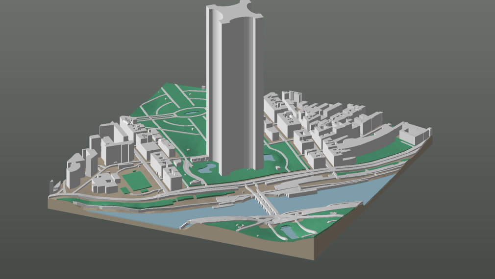
Print a square of Paris and everything in it is right except the one thing you framed it for. The streets are the streets, the Seine is the Seine, the blocks along the river stand at the heights the map gives them — and the Eiffel Tower is a solid column with a lid on it.
Nothing has gone wrong. OpenStreetMap has the tower mapped exactly: a 125-metre square where its four piers stand, tagged 330 metres tall. Extrude that outline to that height and a column is the honest answer. The shape simply is not in the data, and no amount of care with the data will put it there.
Four ways a landmark goes missing
The Eiffel Tower is the obvious case and the rarest one. Far more often the map has a number and the number is true of the wrong part of the building.
- The tag is true of something else. St Paul’s is tagged 35 m, which is Wren’s screen wall and is correct about it — under a dome that reaches 111 m. St Vitus in Prague is tagged 15 m, which is the aisle, on a cathedral whose south tower is 102.8 m. Neither number is a mistake.
- There is no height at all. The Colosseum carries none, so a building 48.5 m tall is left to an estimate made from its own footprint, comes out at 12.7 m, and prints as an oval pancake two and a half millimetres thick. Hallgrímskirkja carries none either, in the city this studio opens on.
- One outline, many heights. Notre-Dame is a single shape tagged 96 m — the tip of the flèche — so the nave, the aisles and the open sky between the towers all extrude to spire height. The Zuiderkerk in Amsterdam is the same fault measured by lidar: 61.2 m is a true measurement of the tallest thing inside that polygon, and the tallest thing is the tower.
- The silhouette is the whole subject. A lattice tower, a dome, a pyramid, an arch, a statue. Here the map is not wrong about anything and the shape is still absent.
The one that stings is the second. Westminster Abbey has no height and two storeys recorded, so it prints as eight metres of garden wall — two hundred metres from a clock tower this studio draws properly. A monument beside a cube is worse than two cubes.
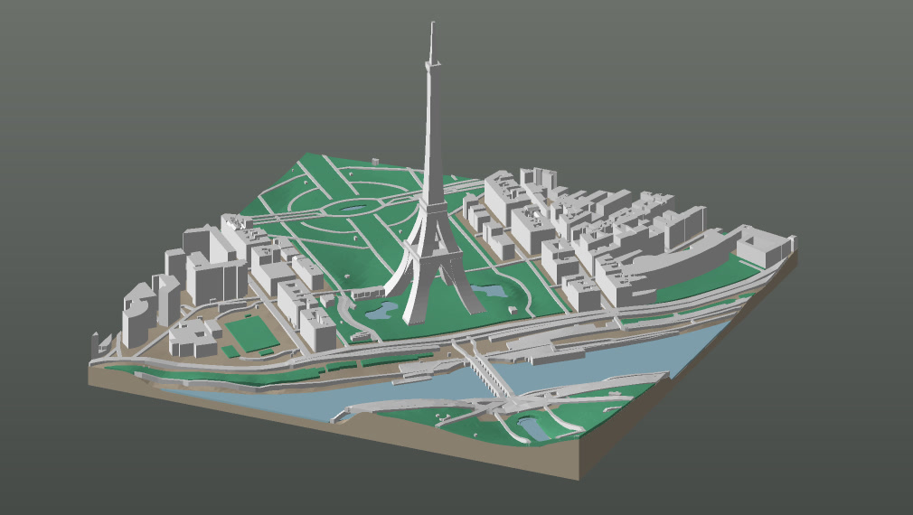
A monument is a column of numbers
The fix is not a downloaded model. Almost every landmark mesh published on the model-sharing sites is licensed against commercial use or against derivatives, and even where that were not true it would be the wrong object: the Eiffel Tower’s girders are half a metre to two metres across, which at 1:5,000 is a tenth of a millimetre to four tenths — at or under the width of one nozzle. So a slicer throws most of them away and what survives is a fuzzy, weaker version of the same column. Detail under a nozzle is not detail. It is noise.
So each monument is written out instead, as a stack of cross-sections in real metres above the ground it stands on. A width at every height where the shape changes, and nothing else. Hallgrímskirkja’s tower is four of them, from 6.5 m at the base to 0.4 m at the tip of the 74.5 m spire — 48 triangles. The whole church, stepped wings and all, is eighteen sections and 248 triangles, for the building Reykjavík is recognised by.
Writing them rather than downloading them buys two things. Every dimension stays checkable against the published drawing it came from, so a file can be read and argued with. And because the numbers are metres rather than millimetres, the same monument prints correctly at any plate size the studio sells, with anything narrower than a nozzle quietly widened until a printer can make it.
And it has to come off the plate
A shape somebody authors is the only place in this pipeline where a modelling decision can quietly produce something unprintable. An extruded outline is vertical and cannot overhang; a spire, an arch or a platform can. Three rules, and they are checked rather than intended.
- Nothing overhangs. Every face stays within 45° of vertical, so each layer is carried by the one under it. A horizontal ledge prints as strings drooping into air, and at this scale there is no room for a support anybody could pick off afterwards.
- A gap is crossed by an arch, never a lintel. An arch carries itself, each layer overstepping the one below by a fraction of a nozzle — and it is drawn pointed rather than round, because a semicircle is horizontal at its crown and would print that last course over open air.
- Nothing narrow stands tall. A spire, an antenna, a minaret leg: anything carrying itself more than ten times its own width on a section too thin to have a core is widened until it is not. This is the failure that hides — it passes every other test, then whips off the plate under the nozzle.
All forty-eight are sliced at 0.2 mm and measured: no unsupported area anywhere, nothing under a nozzle, and the worst slender run in the registry carries 8.4 times its own width against a limit of ten. They print with no supports, like the rest of the plate.
Following the rules is usually a matter of finding the structure the real building already has. The Eiffel Tower’s first platform was a flat slab standing proud of the legs that carry it — 135 mm² of ceiling printing over open air — until it was rebuilt as what it actually is: a ring on four arches, with the middle open.
What it costs on the plate
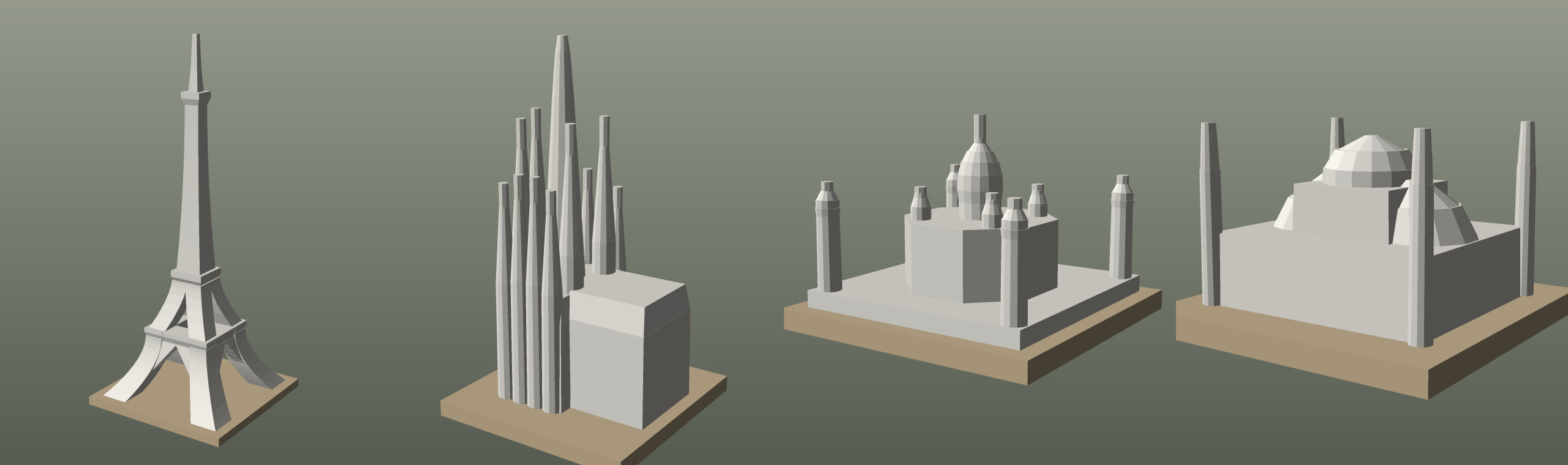
Almost nothing, which is the point of drawing a silhouette rather than a building. The whole registry — forty-eight monuments, 801 sections — comes to 16,832 triangles. On a real 16 cm plate of the Champ de Mars the Eiffel Tower is 1,356 of the 87,346 on it: 1.6%. Most entries are under half a per cent of the plate they stand on.
They print in the same white filament as every other building, in the same pass, with nothing to assemble. A monument is not a separate object you glue on afterwards — it is part of the same watertight solid as the street it stands in, and it costs nothing extra.
Forty-eight, and one thousand four hundred and seventy-six to go
Forty-eight are drawn today: the Eiffel Tower, the Colosseum, the Taj Mahal, Hagia Sophia, the Burj Khalifa, the Sagrada Família, three pyramids at Giza, five monuments of Rome, and a fish market in Gothenburg. The queue behind them runs to 1,476 more across some three hundred cities, and it is written down rather than remembered.
Which one is drawn next is not alphabetical. A monument standing in a frame this studio already sells is worth more than a more famous one nobody’s plate holds, and a file that fixes four monuments in one square is worth four times a file that fixes one — because the failure being avoided is not really the missing tower. It is the tower standing beside a cube.
If the one your city is known for is still a block, that is a gap in the queue rather than a limit of the thing. Everything else on the plate is already right.
Passing it on
The film at the top of this page is free to use, and so are the words below it. Press Copy and it is on your clipboard. The film itself, the vertical cut for a phone and both posters are in the press kit on the launch post.
Monument reel — LinkedIn
Goes with the film at the top of this page. Upload the square cut natively rather than linking it.
OpenStreetMap knows exactly where the Eiffel Tower is. It has no idea what it looks like.

It is mapped as a 125-metre square where the four piers stand, tagged 330 metres tall. Extrude that and you get a solid column with a lid on it — which is the honest answer, because the shape is not in the data.

That is the commonest way a 3D-printed city loses the one building you framed it for, and it happens four different ways:

→ The tag is true of the wrong part. St Paul's is tagged 35 m — Wren's screen wall — under a 111 m dome. St Vitus is tagged 15 m, which is the aisle.
→ There is no height at all. The Colosseum has none, so a 48.5 m building is estimated from its own footprint at 12.7 m and prints as a pancake two and a half millimetres thick.
→ One outline, many heights. Notre-Dame is one shape tagged 96 m, so the aisles extrude to the tip of the flèche.
→ The silhouette is the whole subject — a lattice tower, a dome, a pyramid — and nothing is wrong with the data at all.

So GeoFilament draws them by hand. Not downloaded meshes: at 1:5,000 the Eiffel's girders are thinner than a printer nozzle, so a slicer would throw them away anyway. Each monument is a column of cross-sections in real metres — a width at every height the shape changes at — which stays checkable against the published drawings and prints correctly at any size.

Every one of them has to come off the plate without supports: no face past 45° from vertical, every span crossed by an arch rather than a lintel, and nothing narrow left carrying itself more than ten times its own width.

Forty-eight are drawn. The whole registry is 16,832 triangles — the Eiffel Tower is 1.6% of the plate it stands on.

geofilament.mochi.is

Map data © OpenStreetMap contributors (ODbL)
Monument reel — Instagram, TikTok
For the vertical cut. A link is not clickable there, so the address is said rather than linked.
Your city's landmark is not a box.

The map knows where the Eiffel Tower stands. It does not know what it looks like — it is a 125 m square with a height on it, and extruding that gives you a column.

So they are drawn by hand instead. Each monument is a column of numbers: a width at every height the shape changes at, in real metres, checked against the published drawings.

And every one has to print without supports — no face past 45°, every gap crossed by an arch, nothing thin left standing tall.

Forty-eight so far. Frame yours and it comes off the plate as itself.

geofilament.mochi.is

#3dprinting #3dprint #bambulab #architecture #citymap #maps #cartography #eiffeltower #urbanism #makersgonnamake
One line
For a directory entry, a newsletter blurb or an app-store subtitle.
GeoFilament draws a city’s landmarks by hand, so the building yours is known for comes off the plate as itself rather than as a block.